Time span: October 2020 - September 2023
Project lead: Eurac Research, Bolzano, Italy
Partners within the scope of the Group on Earth Observations (GEO) Global Network for Observations and Information in Mountain Environments (GEO Mountains):
Call: 1st GEO Biodiversity Observation Network (GEO BON) – Microsoft joint call: EBVs on the cloud


Project background
Motivation
The Group on Earth Observations Global Network for Observations and Information in Mountain Environments, GEO Mountains, is a GEO Work Programme Initiative that seeks to connect and facilitate access to diverse sources of mountain observation data and information at different scales. At a recent GEO Mountains workshop, experts on mountain ecosystems were convened to identify and prioritize Essential Biodiversity Variables (EBVs) that are considered relevant for mountains, using the GEO BON EBV framework as a starting point. For the EBV class on Ecosystem Structure, the EBVs Ecosystem extent and Ecosystem fragmentation were identified as priorities to monitor and better understand changes in mountain ecosystems and their species-level biodiversity. Both EBVs require the mapping of ecosystem occurrences and ecosystem distributions to determine the area occupied by ecosystems (Ecosystem Extent) and how and where those areas are reduced due to natural and human-caused disturbances (Ecosystem Fragmentation).
AI4EBV aims to use Artificial Intelligence (AI) to derive accurate, high-resolution maps of mountain ecosystem extents by exploiting both the advanced feature extraction capabilities provided by AI-based algorithms and the computational power of cloud-based platforms. Via the incorporation of the latest Earth observation data, we seek to produce these maps through time, thereby enabling a comprehensive assessment of ecosystem change and fragmentation.
Research questions
The project makes use of the World Terrestrial Ecosystems (WTE) map that was recently produced by Sayre et al. (2020) at a spatial scale of 250 m. While the WTEs map offers a unique spatial representation of terrestrial ecosystems, several open questions regarding its utility for a broad range of stakeholders remain:
- How accurate is the map of ecosystems for mountain regions?
- Can high-resolution Earth observation data be used to improve the spatial resolution and thematic content of the WTE map?
- Can the WTE map be updated based on Earth observation data?
Study regions
Our study regions are two contrasting mountain regions: the Central European Alps and the Himalayas, where accurate and timely reference data are available.
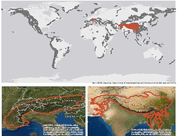 The study sites in the two mountain regions of the Central European Alpas and the Himalayas.
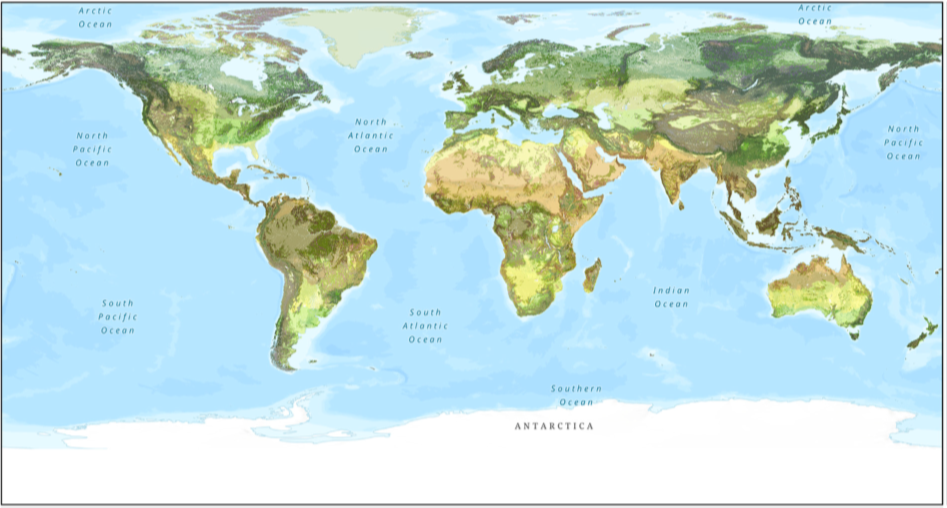
World Terrestrial Ecosystems
The World Terrestrial Ecoystems after Sayre et al. (2020) were developed using the United Nations Food and Agriculture Organization (FAO) and Intergovernmental Panel on Climate Change (IPCC) criteria for ecological zones and climate regions. The map is based on a spatial integration of climate zones, landforms and land cover:
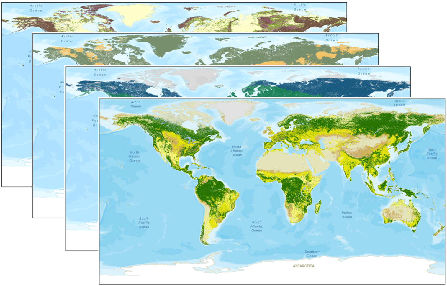
A World Temperature Domains layer was developed by analyzing thousands of meteorological stations over a 30-year record of observations.
A World Moisture Domains layer was similarly developed from precipitation observations.
A World Landforms layer was derived by aggregating the global implementation of the Hammond landforms after Karagulle et al. (2017).
A World Vegetation and Land Cover layer was derived from the ESA CCI global Land Cover product 2015.
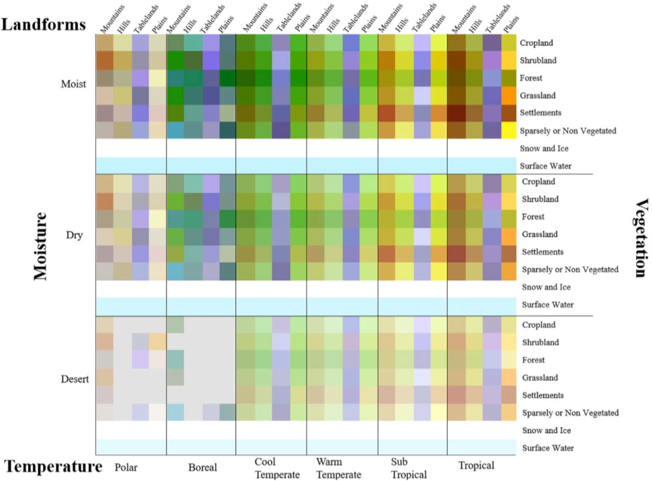
The combination of the climate and terrain types with the land cover types produces 576 possible combinations of World Terrestrial Ecosystems, of which 431 were realized:
The full methodological details and input layer descriptions are found in Sayre et al. (2020).
Methods
The address the research questions, we focus on three different approaches:
- Using AI and ground control points in the two mountain regions to assess the accuracy of the WTE data for those areas
- Direct spatial downscaling of the existing 250 m ecosystem map to 30 m using high resolution EO data.
- Downscaling of the WTE land cover information to generate first a high-resolution land cover map and convert this into a high-resolution ecosystem map following the approach by Sayre et al. (2020)
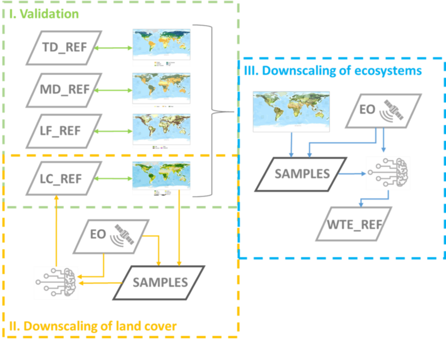 Flowchart of the proposed approach to validate and downscale the World Terrestrial Ecosystems product using high-resolution Earth observation data.